| The National and European long distance paths E4, E6 & O in Greece |
|
The network of the National and European long distance paths in Greece Map of Greece (all the paths) Maps of Greece (E4) Maps of Europe (E4, E6) E4: Detailed description of Routes E4: Detailed map of altitudes and times E4: New routes in the border with Bulgaria E4: Description of the part of Creta E6: Detailed map of altitudes and times |
| A big Thanks you to EOOA and (+)Anastassios Rigas for all the material. The map is hand-made by A. Rigas. |
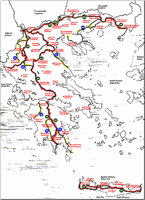
| Although we planned the course the two European long-distance-paths so well, it was impossible to show the rare variety of the Greek landscape to the hiker. So, we marked 7 more footpaths, four in Northern Greece and Thessalia and three in Peloponnese, which complete the European long-distance-paths and form a network of footpaths. This network allows the hiker to leave the long-distance-footpaths at certain points and continue the hike on the so-called national footpaths. In Northern Greece, the the long-distance-footpath 01 gives the possibility to hike from Metsovo over the mountains Peristeri (2.295 m) and Kakarditza of Epirus in Thessalia and then meets the E4 meets at Elati. The 03, gives the possibility to start from Ioannina, climb mountain Mitsikeli (1810 m), and further to Kipi and Monodendri into the famous Vikos Gorge; it spreads through and the mountain-massifs of Timfi (2.497 m) and Smolikas (2.637 m), and finally to the mountain Gramos (2.520 m) at the Albanian border. 03 merges with the E6 again with Nestorion. The 02 allows the hiker to admire the wild landscape of the Olymp into the level of Thessalia, to climb Ossa (1978 m), and then in a 4-day hike to arrive at the coasts of the aegean sea at the foot of Pilion. The 04 is not final in his marking. It is planned to connect as the southern branch of the E6 to Thessaloniki over Chalkidiki and South Makedonia with Xanthi in Thrace. At the moment, only the part of Amphipolis is marked over the ridge and the summit of the Paggaion mountain until Nikissiani and Elefteroupolis. The ascent of the summit gives the hiker a splendid gaze to the sea and to the level of Philippi. |
In Peloponnese the path 31 connects Patra with the small city of old 0lympia. From the city Patra, where the ferry from Italy anchors, one can reach Olympia after a 5-day hike. Peloponnese, mainly an island, has many places to see and remains of the well-known greek ancient History. What the E4 cannot offer the hiker, is done by two long-distance-footpaths, 32 and 33. The footpath 32 starts at Vytina (E4) and gives the hiker the possibility to descend the green canyon of Loussios river, visit and two ancient convents, reach the slopes of mountain Taygetos (2407 m) and spread through the ridge in its whole length, up to the summit. Furthermore, through the famous Viros canyon the hike lasts 8-10 hours to the coast, to reach the Messenian golf at the small city Kardamili. In the canyon, tracks of ways are to be seen from antiquity. The footpath 33 begins at the village Agios Petros (E4) and proceeds at the eastern slopes of Parnon mountain and on its ridge up to the summit (1936 m); from there the ridge descends to the lighthouse of cape Maleas. The view from the ridge to the Aegean is unforgettable. The way drives to swimming sites furthermore. | |